LifeScienceHistory.com - Check us out on Instagram
Take Your Next Career Step with Lundback
Geography & Climate
Industry Overview |
Economy/Cost of Living
Education |
Recreation & Entertainment |
Transportation
History |
Suggested Reading List
 New Mexico is located in the southwestern region of the United States. It contains 121,365 square miles (314,334 square kilometers or 31,433,391 hectares) of land, and 234 square miles (606 square kilometers or 60,606 hectares) covered by water. The state’s total area of 121,598 square miles (314,937 square kilometers or 31,493,737 hectares) makes it the 5th largest among the United States. New Mexico is bordered to the west by Arizona, to the north by Colorado, to the south by Texas and the international border of Mexico, and to the east by Oklahoma and Texas.
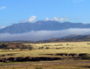
New Mexico is divided geographically by the Great Plains to the east, the Rocky Mountains and Rio Grande river centrally, and the Basin and Range region to the south of the Rockies. New Mexico’s highest point is Wheeler Peak at 13,161 feet (4.01 kilometers) above sea level, located in the Sangre de Cristo Mountain range. The state’s lowest point is 2,842 feet (866 meters) above sea level at the Red Bluff Reservoir. Major rivers include the Rio Grande, San Juan, and Pecos Rivers.
The state’s topography is distinguished by its mountains, mesas, deserts, and forests. Rainfall is scant in New Mexico’s arid climate. The mostly sunny climate is significantly influenced by elevation. Summer temperatures average around 90 degrees F (32.2 degrees C) in lower elevations and in the upper 70’s in higher elevations. Winter temperatures average at about 55 degrees F (12.8 degrees C) in the southern and central valleys and about 35 degrees F (1.7 degrees C) in the higher elevations northward. Annual precipitation averages less than 10 inches (25.4 centimeters) in the southern desert regions to more than 20 inches (50.8 centimeters) in higher elevations.
Related Resources
Return to Destination New Mexico